

Landmarks in Pampanga:
Rivers:
1 Pampanga River
The Pampanga River is located in Central Luzon
(north-west of Metropolitan Manila) and passes
through the provinces of Pampanga, Nueva Ecija,
Bulacan, Tarlac and Quezon. During the Spanish
period, the river was known as the Rio Grande de
Pampanga. It is the second largest river in Luzon
and fourth largest river basin in the Philippines.
2 Abacan River in Pampanga
Abacan River is one of the largest water channels in Pampanga (channeled from Angeles to Mexico). The River ends into the Pampanga River. The Lahars flow follows the riverbed during Mt. Pinatubo`s eruption.3 Sacobia River In Pampanga
Sacobia River is one of the main streams in Pampanga. The debris and Lahars from Mt. Pinatubo 1991 eruption follow this river as well. Before this occurrence the native Aetas living along riverside. After the eruption, everything along the river was devastated. The river bed widens and up to now (in the year of 2013) the hardened Lahars are still visible on the Sacobia River bed.4 Gumain River in Pampanga
Gumain River was covered with vast of sands and lahars during the eruption of Mt. Pinatubo as well. Before the 1991 eruption, its waters come from Mt. Abu in Zambales. The river serves as a passageway for Aetas on the way to the lowlands.5 Pasig Potrero River in Pampanga
Pasig Potrero River became famous during the eruption of Mt. Pinatubo. The lahars and pyroclastic materials pass into this river. It was the main focus of authorities’ observation during the time of eruption.6 Candaba Swamp in Pampanga
Candaba Swamp it is located in the middle of the rice field of Candaba, Pampanga. Candaba swamp is well-known for his sweet watermelons out of this zone. It is also noted for “Tilapia” (A dinning Fish species). Candaba Swamp got International attention true the bird migratory known as the “Candaba swamp”.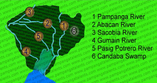


Landmarks in Pampanga:
Rivers:
1 Pampanga River
The Pampanga River is located in
Central Luzon (north-west of
Metropolitan Manila) and passes
through the provinces of Pampanga,
Nueva Ecija, Bulacan, Tarlac and
Quezon. During the Spanish period,
the river was known as the Rio
Grande de Pampanga. It is the
second largest river in Luzon and fourth largest river basin in the
Philippines.
2 Abacan River in Pampanga
Abacan River is one of the largest water channels in Pampanga (channeled from Angeles to Mexico). The River ends into the Pampanga River. The Lahars flow follows the riverbed during Mt. Pinatubo`s eruption.3 Sacobia River In Pampanga
Sacobia River is one of the main streams in Pampanga. The debris and Lahars from Mt. Pinatubo 1991 eruption follow this river as well. Before this occurrence the native Aetas living along riverside. After the eruption, everything along the river was devastated. The river bed widens and up to now (in the year of 2013) the hardened Lahars are still visible on the Sacobia River bed.4 Gumain River in Pampanga
Gumain River was covered with vast of sands and lahars during the eruption of Mt. Pinatubo as well. Before the 1991 eruption, its waters come from Mt. Abu in Zambales. The river serves as a passageway for Aetas on the way to the lowlands.5 Pasig Potrero River in Pampanga
Pasig Potrero River became famous during the eruption of Mt. Pinatubo. The lahars and pyroclastic materials pass into this river. It was the main focus of authorities’ observation during the time of eruption.6 Candaba Swamp in Pampanga
Candaba Swamp it is located in the middle of the rice field of Candaba, Pampanga. Candaba swamp is well-known for his sweet watermelons out of this zone. It is also noted for “Tilapia” (A dinning Fish species). Candaba Swamp got International attention true the bird migratory known as the “Candaba swamp”.